


|
|
|
|
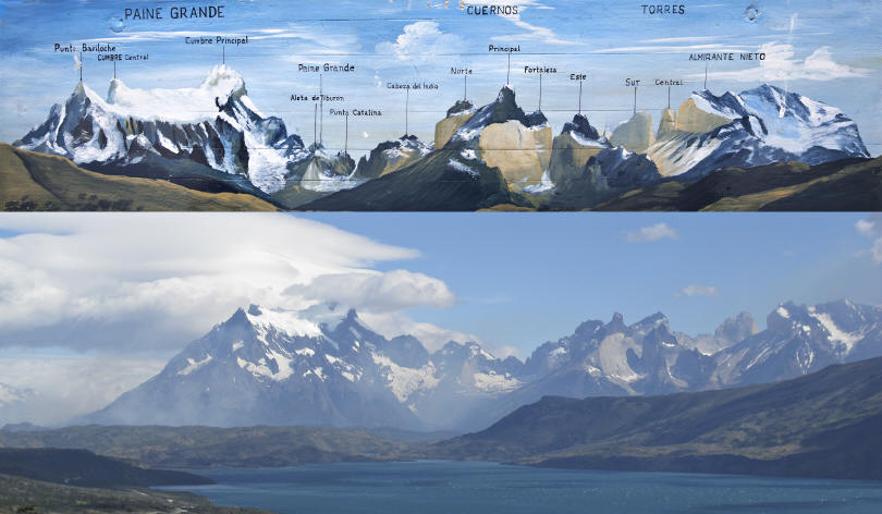
Dec 27 – Tues. It was a long night. We arrived in the Chilean Punta Arenas Airport around 12:20 pm. We are really down south now – 51 lat south (SF is 42 lat north). Our pickup was a drama scene after waiting at least 30 minutes for someone to show up. When the Patagonia Camp representative arrived she informed us (another couple as well) that we would have a 4 hour wait. Not going to happen. We took the van slated for the 4 pm pickup and after a few more drama scenes – departing couple – we were on our way at 2 pm with Dickie (sic), the driver, for our 4 hour ride to the Camp. The scenery was not exciting since it was mostly pampas with sheep and llama ranches sparsely scattered along the road. What was exciting was our van ride. It seems that either Dickie is a neophyte roadman, sleepy or otherwise impaired. He could neither keep a constant speed nor drive a straight line. At one point, Care tried to huddle up and sleep in the back in order to keep warm since the air conditioning was going full blast. However, when she sat up, the view out of the front window was a semi-truck coming straight at us. She yelled. Dick pulled over in the right lane and slowed way down and continued in this manner for a number of miles. Meanwhile, the gas gauge drops to empty, we are in the middle of the nowhere and Dickie say “no problemo”. Sweet. As we near Puerto Natales, a small port town, we plead for a bano. Dickie finally pulls into a gas station, we take a break, he gases up and we ply him with caffeine. Another hour, we pull into the cove where the Camp is situated south of the Torres Del Paine National Park in Patagonia, Chile. It is a fairly large (19 yurts), well established and comfortable eco-lodge. It reminds us of a high-end fish camp in Minnesota or Alaska. So we look at our watches and it dawns on us that we are really south – and that the days are no longer 12 hours but instead have shifted to 17-18 hours of day light. Dinner is at 8 or 9 – it could have been lunch by the sky. We move into our yurt, with a bottle of wine and sit and enjoy the view of Lago Toro. We have a briefing for the next day but before we finish dinner the plans for our hiking tomorrow have changed due to a fire in the park. We need sleep. Dec 28 – Wed. The sun comes up early but we manage to catch up on
sleep until 8 AM. Reminder, this is our vacation so we are entitled to a few
mornings of leisure: drinking coffee, relaxing, etc. We start today’s low key
adventure by driving the 13 km to the Park entrance and then on to a small area
at the south end of Lago Grey. The National Park situated at the southern end of
the Andes is a fairly new park and bears the UNESCO World Heritage Reserve
distinction. The Park is filled with glaciers, lakes, mountain meadows, and
dramatic scenic views plus great hiking. We arrive at Lago Grey and were blow away, literally. We had heard about the
gusts of wind in Patagonia but nothing prepared us for 7 hours of non-stop gale
force winds. We weren’t really cold but sometimes standing erect was quite a
challenge. We walked across the Lago’s beach and viewed the pieces of ice that
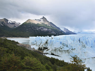
have broken away from glacier and floated south just off shore. After a picnic lunch, we move on to a short hike overlooking Lago Pehoe. Here, supposedly the world’s record salmon catch was recorded at ~120 lbs. from this area. We had great southern views of the confluence of the Lago Sarmiento and Lago Toro from our vantage point. Amazing how much energy the wind saps out of you when hiking against it. By 5 we return to the lodge and are ready for a shower. Dec 29 – Thur. The news of the fire in the National Park is not encouraging. Although the winds have died down this morning, the reports are for 75-100 mph winds this afternoon. The “W” and “O” trails are closed. Yesterday, we observed the firefighters preparing to take off by zodiac on Lake Grey. We learned that the high winds kept the men from landing on the eastern shore of the lake. Yesterday, our afternoon walk took us to the Posada Rio Serrano where we could look down on the administrative center (former sheep ranch). We learn today that the fire has moved south into this area. Six Israelis are said to be responsible for setting the fire in a non-camping area and it got away from them. The authorities have 3 in custody but 3 are unaccounted for. Although the Park remains open, the fire has disrupted our plans to hike in the area between Lago Nordenskjold and Lago Sarmiento, Sendero Observacion Fauna, due to the amount of smoke in this direction. We ended up leaving the Park and heading down to the Cueva Del Milodon National Mounument. This area was home to the primitive Patagonian man of 12,000 and 9,000 years ago as well as the large mammal herbivore, milodon. There are 3 major caves and a rock formation of The Devil’s Chair. From the site, Puerto Natales is visible across the flats which were once glacial cover. Since our options for hiking are limited, we made a 3.75 mile walk to a nearby waterfall at the Patagonia Camp. It remains unknown whether the Park will allow us to travel to the eastern glaciers tomorrow since there is no way we will be able to do any major hiking around the Towers, etc. Dec 30 -Fri. Last night we continued to receive gale force winds with no break. We woke to smells of smoke and visual banks of smoke hugging the mountains. By 9:30 we knew that our trip to the eastern glaciers would be cancelled. The Park was heading to a complete closure and evacuation of the lodges situated in the Park. This closure may continue for over 30 days which put an employment hardship for many lodge workers and guides. Jon with another couple from Manchester decided they wanted to go horseback riding this afternoon. The headed out toward Puerto Notales and the hill over looking the town. It was about 1 1/2 hour drive each way. They had great views of surrounding area. Care stayed in the lodge to sleep off a pesky head cold. Dec 31 – Sat. Although the wind has subsided, we are breathing smoke consistently in the camp now. The wind direction changed so the fire will be pushed backward where it has already used the available fuel. Hopefully this will give the fire crews more of a chance to contain it. We leave Patagonia Camp and head toward El Calafate, a 6 hour drive including our border crossing into Argentina. The landscape is very flat, scrub like with cattle and sheep ranches dotting the way. We pass through El Calafate with a brief stop for exchanging money. The town, 22,000, exists primarily on tourism and the streets are lined with shops filled with mountaineering gear. It is not completely possessed by the backpacker crowd. About 20 minutes outside of town is the Eolo Lodge situated on a hill over looking the town and distant glacier bays. When we arrive we are told that dinner will be at 9 PM due to the New Year’s Eve celebration so Jon orders his first Argentinean beef dish for lunch. We explore the property afterward including the indoor pool. Jan 1, 2012, Sun. It is a beautiful morning with the sun rising over the pampas throwing light on the cattle, wild hares, and birds grazing outside of our window. El Calafate is situated on the south shore of Lago Argentino, in the Santa Cruz province. The province itself is the second largest in size in Argentina, the largest being Buenos Aires. However, its population density is sparse. The town of El Calafate is the gateway to the National Glaciers Park and consequently serves as the tourist center for those who come to visit the glaciers. Within easy access by car or boat is Glacier Perito Moreno and the Glaciares Spegazzini and Upsala are visible by boat. Further north is Lago Viedma from which Mt Fitz Roy is accessible. We spend the day at the Moreno Glacier. It is named after Argentina’s
favorite explorer, Francisco Moreno, El Perito, who traveled throughout
Patagonia in the 1870-90. He was instrumental in advising the Chile-Argentina
border negotiations for which he received a grant of land near Bariloche. This
he turned over to the government to manage – an act that catalyzed the creation
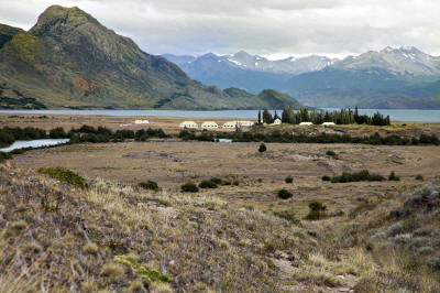
of the national park system of Argentina. The Moreno Glacier is one of the few advancing glaciers in the world. Approximately 30 km long, it reaches water at a narrow point in one of the fiords, Brazo Rico, opposite Peninsula Magallanes. It is here 5 km across and 60 m high that is forms a dam across the arm of the Argentina Lake separating the waters of the Brazo Rico and Brazo Sur. When the water is ~100 feet higher than the main body of lake (Canal de los Tempanos or Canal of Icebergs) the glacial dam can no resist the water pressure and the waters demolish the glacier and rush into the Canal in about 12 hours. This phenomena used to occur every 3-4 years but now there are mini breaks annually thought to be the result of global warming. We spend our time in the National Park situated on the bank of the Canal de Los Tempanos opposite the glacier at various orientations and levels of viewing, provided through the elaborate set of metal boardwalk/stair steps finished recently. We found the views to be extraordinary considering how close we actually were to the Glacier without being on top of it. We lunched on one of the decks overlooking the glacier and listened to the calving and ice releases while we ate. After completing the hiking loop we returned to an afternoon of relaxing on the Eolo’s outside deck watching the cattle below us and an occasion group of horseback riders. Jan 2, 2012. Mon. We leave El Calafate early to catch the boat at Punta Bandera on Lago Argentino to Estancia Christina located in a remote northern channel close to the Upsala Glacier. The Glacier is named after the Swedish city in which it’s university sponsored the first glacier study in the region. It has 2 terminal tongues of approx 4 km wide each. The surface is870 km and length is 60 km.The Glacier is experiencing backward movement with evidence of ice loss in its front all year. From our boat we view the huge ice floes floating in the lake. After viewing Upsala from the boat, we continue on for another 30 min to
Estancia Christina. It was established in 1914 by Joseph P. Masters and his wife
Jessie who both came from England seeking land for a sheep farm. After exploring
and working in Santa Cruz for several years they choose this solitary location
in an isolated valley surrounded by waterways, lakes and mountains. It
eventually was named after one of Masters’ children when she died unexpectedly.
Her brother went on to take care of his elderly parents and run the ranch. He
later married the woman hired to care for his aging parents although the had no
children to continue the Master line. In 1999, when the last relation died the
property was turned back to the park service who continued to operate it as a
tourist destination. We take lunch and check into our rooms which are very modern and comfortable. There are only 20 room with 40 people at a time. All meals are included since we are a captive group. In the afternoon we take a guided tour of 6 miles to Cerro Cameron where we have a stunning view of the Upsayla Glacier from across the valley. Jan 3 – Tues. The wind howled throughout the night and our room creaked and knocked but remained solid. After breakfast, 26 of the guests trundled out for a 4×4 drive up a nearby mountain to a major look-out of the Upsala Glacier. On the way we passed the boat built by the Masters’ family but destroyed when the Argentina government wanted to confiscate it since there were no formal papers of its existence. A canyon along the way had been subject to slash-and-burn by the family; however, the trees remain preserved due to the microclimate. We disembark to a very rocky, windy trailhead where we walk about 1/2 mile further to a fabulous view of the glacier. Upsala is the second largest glacier in Argentina. Its profile floats on the water which explains why the lake is filled with ice floes that have broken off from the glacier at the mouth of the channel. The Glacier Moreno in contrast is a deep water glacier that touches the lake bottom and reaches upward above the lake level. It breaks pieces from the roots upward causing the deep crashes of ice falling or calving sometimes 90 degrees to the lake. We start our return trip through the glacier valley and then move on to the valley of fossils where squid fossils and anemone are evidenced in the rock strata. There are layers of sedimentary rocks followed by lava flows hardened on top of water pools. Gazing up the high red canyon walls, it is reminiscent of the Grand Canyon. We stop at a sheltered lake to consume our box lunch we created this morning at breakfast. Our guide points out paw prints from a mother and baby puma. However, we have been hearing about the elusive puma for three countries now (Peru, Chile and Argentina) and none have made themselves visible to us. After returning to the valley floor, we are within an hour of the ranch. We complete our 8 mile outing early afternoon. Although we missed the call for an afternoon horseback ride, we will be able to take one tomorrow before returning to El Calafate. Jan 4 – Wed. We awake to a clear and relatively warm day. Needless to say the wind continues to howl in spite of the temperature rise. We are going to spend the day horseback riding on the Estancia so we pack a box lunch of salad and snacks and put it in our saddlebags for later. Around mid morning we are outfitted with our horse, helmets, etc. and we are ready to go. It is a beautiful route in which each vista surpasses the next one. We ride several hours returning to the canyon of fossils in which we had trekked the previous day. Although we were a fairly large group the gauchos were able to handle the mixture of horse riding abilities. We took lunch at a high lake where there was some shelter from the wind. We ride past the chapel built in early 2000 when a tragic plane crash killed several of the landowners. This was a memorial created in their remembrance by their families. Our return ride was shorter and put us back into camp in time to have some refreshments and regroup before getting on the boat returning to El Calafate. We arrived back about 7:30 pm, checked back into the Eolo Lodge, took a shower and wound up at dinner after 9. Since the Amazon, our nightly meals have been drifting later and later. The long days lull us into later activities which pushes dinner much later. It is preparing us for Buenos Aires which is renown for late supper. On to Buenos Aires
|
|
|